Josephus–affectionately dubbed Brosephus in my household–now comes to you, via Carta Jerusalem, with full-color illustrations. I’m still coming back to these three new titles, but in the meantime, here’s a bit of info about Carta’s Illustrated The Jewish War by Josephus.
The publisher describes it thus:
A modern reading of Josephus’ ancient text, profusely illustrated, and placed against its geographical historical background.
• 40 maps illustrating the events recorded by Josephus referenced to the latest scholarly research (The Carta Bible Atlas, The Sacred Bridge: Carta’s Atlas of the Biblical World, and more);
• 175 illustrations of sites, archaeological finds, landscapes, artifacts, and artist’s renditions;
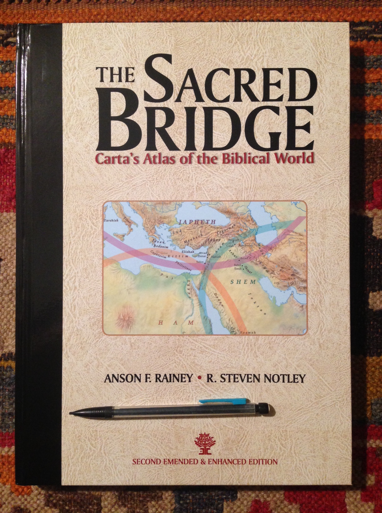
The Sacred Bridge, as I suggested in probably the longest review I’ve written on this site, is pure gold. R. Steven Notley, a co-author of The Sacred Bridge, has written the introduction for this new volume. It is not very long, but Notley does not need many words to orient readers well to the subject at hand.
The translation is William Whiston’s. The illustrations, maps, and other images (not to mention the color coding that makes even a small-font, tour de force like The Sacred Bridge readable) look to be a nice enhancement to Josephus’s text.
I’ve not seen more than the sample pages, but a possible desideratum could be additional study notes, or footnoted annotations throughout the text to keep the reader oriented to The Jewish War. The images appear to serve that purpose in at least some measure, and promise to make for yet another beautiful book from Carta.
Through the end of June the discount code 30-off will get you 30% off the hardcover volume (retails at $60). The book is to be published in early June. You can find it here.
Carta–one of my favorite publishers–has just announced the release of some new titles. As with anything I’ve seen from Carta, they each look fascinating and thorough, even if the books themselves are brief.
Thanks to Carta, readers of Words on the Word (and anyone, really) can get 25% off a Web order at Carta’s online store. Simply click on any cover image below to go to that title, and enter the code 25-off to receive the discount. The offer is good through December 15 (UPDATE: December 31) or so.
This volume, the second of four in The Carta New Testament Atlas series, presents the latest advances in the history and archaeology of Jerusalem. The last fifty years in particular have seen significantly increased efforts to discover the city’s past. New finds every year render what is previously written almost out of date before the ink is dry. With an acknowledgement of this reality, together with a recognition that much of the Old City of Jerusalem remains inaccessible to archaeological investigation, the present work lays its shoulder to the challenge.
Yes, an entire book (even if only 40 pages) devoted to understanding the state of the boat in Jesus’ time. When I flipped it open yesterday, I found myself drawn to and reading the two-page glossary of terms first! It’s a good sign that even the glossary is interesting. I’m excited to dig in to this one. Here’s the publisher’s description:
The ancient boat from the Sea of Galilee exhibited at the Yigal Allon Museum at Kibbutz Ginosar speaks of pivotal times on the lake two millennia ago, when an itinerant rabbi walked its shores and sailed its waters with his followers, and changed the world forever.
This volume aims to give the non-expert reader an in-depth understanding of the boat, the story of her discovery and excavation and, most importantly, her significance for illuminating Jesus’ ministry by helping us better understand its contemporaneous milieu of seafaring and fishing on the Sea of Galilee.
Understanding the land of Jesus is a necessary component to comprehending the message he proclaimed. From the beginning of the four Gospels until their end, the Evangelists assume that we possess an intimate knowledge of the historical and geographical stage onto which Jesus stepped.
For most Christian readers this is unfortunately not true. Many have not had the opportunity to visit the Holy Land. Even for those who have, it can prove to be a confusing experience. Much about life in this land has changed over the course of two millennia.…
It is hoped that the maps [in this book] and the brief texts that accompany them can serve as a guide for the Christian reader to navigate the geographical stages in the Gospel accounts. …May the reader be aided in their pursuit to follow the steps of the Master and to grasp more clearly the message he preached.
As I have a chance to explore these titles more, I’ll report back. Again, the code is 25-off at Carta’s online store. (UPDATE 2: This code is good for the titles above and anything else in the store, not the least of which is this beauty of a book.) Also, if you have 13 seconds, are on Twitter, and like to share your opinions about printed maps, check out this poll, which particularly has the last title above in mind.
View my reviews of Carta works here. Check out their site here, and go here to see their works via Hendrickson, their U.S. distributor. For the next few weeks, however, the titles above are only available through Carta’s site.
Far and away, The Sacred Bridge is the best Bible atlas–and one of the most impressive books–I’ve ever used. Now Carta is beginning to publish bite-sized adaptations from that massive and beautiful work. In the Master’s Steps: The Gospels in the Land is Volume 1 of The Carta New Testament Atlas, to be released in four total volumes. In the Master’s Steps is “partially excerpted” from The Sacred Bridge (TSB). (EDIT/UPDATE: Volume 2 will not be an excerpt from TSB–it’s a new work.)
The hope of the book, author R. Steven Notley writes, “is that a better understanding of the physical setting and events that framed the life of Jesus can assist us to hear more clearly the message he proclaimed.” Or, as St. Jerome puts it (quoted in this book):
Five gospels record the life of Jesus. Four you will find in books and the one you will find in the land they call Holy. Read the fifth gospel and the world of the four will open to you.
Those of us who have not yet had occasion to travel to Israel will have to settle for books such as Notley’s. However, as one makes her or his way through Notley’s careful writing, the vivid images, and the flawlessly rendered maps–one realizes there is no settling with this book. It’s the next best thing until such a day as one can make it to the Holy Land.
This book does not differ very much from its corresponding TSB sections, though this one is intended for a wider, more popular audience. Owners of TSB do not need to buy this volume, which does, however, carry with it the advantage of being portable, affordable, and concisely addressing the life of Jesus. If you don’t have TSB and are interested in geography and the New Testament, definitely pick up this work.
A few highlights in review:
Like all Carta books I’ve put my hands on, this one is of high quality. It’s paperback, but the thick, semi-glossy paper helps the full-color images really pop, and is perfect for making marginal notes in pencil.
As with The Sacred Bridge there is an index of place names, but not an index of Scripture references. Notley includes plenty of references, especially at the multiple points where he seeks to explain what could be, in fact, a harmony of apparently divergent gospel accounts when it comes to certain geographical details. Or if no harmonization is possible, Notley at least offers side-by-side comparisons.
The content of In the Master’s Steps is culled from chapter 22 of The Sacred Bridge, which, as it turns out, is the chapter I chose to profile most in-depth in my TSB review. Rather than repeat myself here, I simply refer you to my section 4 (“Case Study: The Sacred Bridge on The Holy Gospels”) here. Most, if not all, of what I say about the content there would apply to this book under review.
Here are the chapters of In the Master’s Steps:
The Birth of Jesus and the Flight into Egypt
The Ministry of John and the Baptism of Jesus
The Travels of Jesus
The Sea of Galilee: Development of an Early Christian Toponym
The First-century Environs of the Sea of Galilee
The Last Days of Jesus
Jesus and the Myth of an Essene Quarter in Jerusalem
The Arrest and Death of Jesus
From the Empty Tomb to the Road to Emmaus
Okay, I will quote this one helpful paragraph that leads off chapter 5 of In The Master’s Steps:
Events recorded in the ministry of Jesus outside of Jerusalem are primarily located in the region around the Sea of Galilee, specifically in the north and northwest area of the lake. The Gospels are an important historical witness for Jewish settlement in this region. Scholarship seldom notes that for many of these settlements, their first mention in the literary witnesses is in the New Testament. After a confrontation in the synagogue in Nazareth, his boyhood home, Jesus relocated to Capernaum on the Sea of Galilee (Mt 4:13; Mk 1:21; Lk 4:31). This village would become the center of his ministry in the region. We now turn our attention to settlements around the Sea of Galilee that find mention in the New Testament.
Here is a sample of the graphics and maps to be enjoyed (click on each image to enlarge):
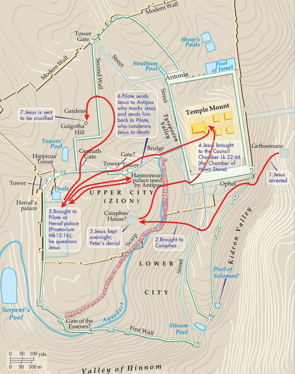
Carta Caption: The arrest, interrogation and execution of Jesus
Around the Sea of Galilee (Carta’s caption)
To book’s hope, to revisit it again, “is that a better understanding of the physical setting and events that framed the life of Jesus can assist us to hear more clearly the message he proclaimed.” Reading through In the Master’s Steps will certainly offer such an understanding for the teacher, student, reader, or person of faith who picks up the book. The connections between geography and theological applications are not often made explicit here, but the reader will have more than enough historical background and imagery to begin to make those associations for herself or himself.
Many thanks to the good folks at Carta for sending the book. They didn’t ask for a review, so I write this of my own volition! I think they are one of the finest publishers in the business today. Check out their site here, and go here to see their works via Hendrickson, their U.S. distributor.
You can find it, for under $90, here at Hendrickson’s site. The accompanying younger sibling volume, Carta’s New Century Handbook and Atlas of the Bible, is $37.
Last week we received a kindness in the mail from a new friend in Israel–F.F. Bruce’s Bible History Atlas.
My 7-year-old son, who had been looking forward to receiving it, came home from school and smiled widely when I had him open it.
He ran outside to share the good news with his younger siblings, who were running around with sticks and dressed up as a spaceman and ladybug, respectively. He was excited.
His first excited question to me when he came back into the house was, “Where is the battle page?” We have again been reading about the Maccabees recently in The Sacred Bridge (though, of course, I had to for now edit out the forced circumcision portion of that narrative!), so he was eager to find the Maccabees and Hasmonean era in Bruce’s atlas, which we were easily and quickly able to locate.
The atlas covers all of biblical history–both Testaments and everything in between.
The kind folks at Carta publish the Bruce atlas, as well as The Sacred Bridge. Their product page for Bible History Atlas (one of many fine atlases they offer) is here.
Is The Sacred Bridgethe best Bible atlas ever? To be fair, people consult atlases for different purposes. But for the one–academic or otherwise–who wants to dig deeply into the historical geography of the biblical world, what’s the best resource available?
I believe the reviewer should evaluate a work according to its merits in relation to the aims of the work. It would not be fair, for example, to criticize a popular commentary for not being technical enough, nor to criticize a work explicitly focusing on the Greek text of a biblical book for not including enough historical background.
So it is perhaps a bit odd that I come to a review of The Sacred Bridge: Carta’s Atlas of the Biblical World (hereafter, TSB) with the question: Is it the best Bible atlas ever? It does not explicitly claim it is, nor self-consciously attempt to be. However, some copy by its publisher, Carta Jerusalem, does read, in part:
The Sacred Bridge will be the Bible Atlas of Record and Standard Work for the coming decades. Exhaustive in scope and rich in detail, with its comprehensive documentation of the Near Eastern Background to Biblical History, this latest Bible Atlas from Carta is one more stepping stone on the way to the study and understanding of the Holy Scriptures.
TSB‘s reputation precedes it. Readers of this blog know that I’m a daily user of Accordance Bible Software. It was from the Accordance User Forums that I first learned about The Sacred Bridge. Almost every mention hailed it as the best, most comprehensive Bible atlas there is. So, naturally, I was eager to test that claim for myself.
In this post I review Carta’s impressive atlas. SPOILER ALERT: The answer to my “Is it the best?” question is… yes.
Such a monumental work deserves an attentive and thorough review, which I offer here as best I can. This will not be a short review, but my aim is for anyone reading it to be able to decide whether to add TSB to their own personal arsenal of resources for reading and study. The review will follow this outline:
Orientation to Orienteering with TSB: What are the ways one can (begin to) use the atlas? I suggest four.
TSB‘s Construction, Layout, and Text: How is the presentation and typesetting in the atlas?
Maps, Images, and Tables: Are the images of high quality? Are they easy to read?
Case Study: The Sacred Bridge on The Holy Gospels: I interact more closely with an individual chapter, Chapter 22: “Historical Geography of the Gospels.”
The Younger Sibling of TSB: Here I point out and briefly comment on Carta’sNew Century Handbook and Atlas of the Bible, which is essentially a condensation of (or, set of selections from) The Sacred Bridge.
A Few Points of Critique: Though this atlas would be difficult to make much better, I offer a few minor suggestions.
Excursus: My Seven-Year-Old Son Loved It: This is true–I have a picture to prove it.
1. Orientation to Orienteering with TSB
A. The Jump-Right-In Method
One way to begin using The Sacred Bridge is to do what I did when I first received it: open it up and start flipping through it.
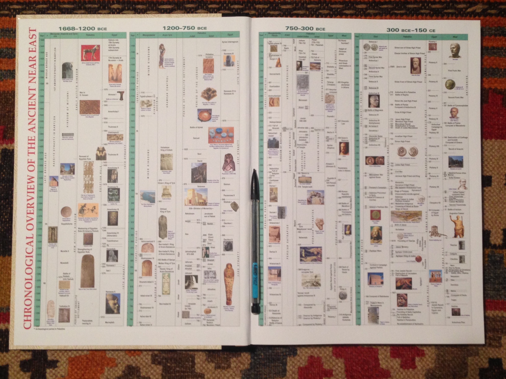
This impressive, detailed timeline greets the reader inside the front and back covers (“Chronological Overview of the Ancient Near East”):
You probably won’t be able to see much detail in the image above, but it’s legible when you’ve got it in front of you.
The Table of Contents are worth perusing, available from Carta here (PDF) or from Eisenbrauns (the North American distributor of TSB) by clicking through from the product page. One immediately notices that the atlas covers from the fourth millennium BCE through the Bar Kochba Revolt (132-135 CE).
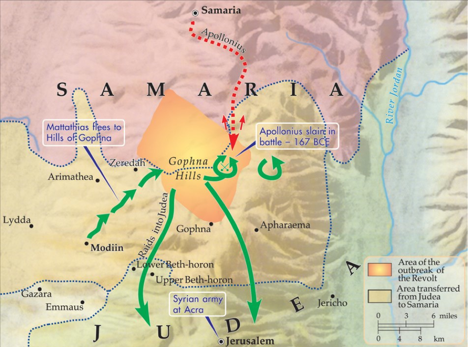
Given my interest in Septuagint studies and Maccabees, I opened right away to Chapter 18: “The Hasmonean Struggle for Independence (167-142 BCE).” It begins:
The response to Antiochus IV’s Hellenizing campaign was quick and forceful. The writings of Josephus and 1 Maccabees recount that Mattathias son of John, a priest and leader in the village of Modiin (el-Midya; Eus. Onom. 132:16; Notley and Safrai 2005:126 n. 703) near Lydda, was one of the first offered an opportunity to submit to the king’s edict (Ant. 12:265–271).
There is also this map, “The beginnings of the Hasmonean revolt, 167 BCE”:
And then, with the battle map in view, “The Early Battles” walks the reader through the battles mentioned in 1 Maccabees 3 and 4 (Gophna, Beth-horon, Emmaus, and Beth-zur), after which subsequent sections follow the Maccabean campaigns of 1 Macc. 5 and following. This particular chapter in TSB reads like a detailed and page-turning military history:
Jonathan’s political position was tenuous. His allies were dead, and the figure he had earlier opposed was now seated on the throne in Antioch. The high priest moved to take advantage of the political diversions in Syria and attacked the Citadel in Jerusalem. Perhaps, he assumed that Demetrius II would follow his father’s pledge to empty the bastion of the Seleucid garrison and turn it over to the high priest (1 Macc 10:32)—an offer his benefactor Alexander never matched. It seems that the son of Demetrius likewise thought it better to maintain a military presence in the Citadel and demanded the Hasmonean cease his hostilities.
B. The Read-the-Introductory-Material Method
Chapter 1, “Dimensions and Disciplines,” informs the reader what kind of book The Sacred Bridge is:
This is not meant to be a textbook in geography, not even biblical geography. It is an attempt to view the geographical setting through the eyes of the ancient inhabitants. It concentrates on the terms and places that have enjoyed their attention; it seeks to define them in terms of their ancient understanding.
In pursuit of this aim, the atlas draws on “every available documentary source, Egyptian, Akkadian, Moabite, Phoenician, Greek, Latin, Arabic, etc., that may provide geographical details and perspective.” Though the first chapter is dense and technical, it alerts the reader to the various kinds of sciences (ecology, hydrology, and so on) that constitute physical geography, as well as covers disciplines like historical philology and “grammatical analysis of ancient Semitic toponyms” (!).
Then, true to the goal of describing places “in terms of their ancient understanding,” the second chapter is short, readable, and informative, titled, “The Ancient World View.” It focuses especially on the economy and commerce of the ancient world.
Chapter 3, “The Land Bridge,” describes the Levant, demarcating just what land the “Sacred Bridge” refers to: “the eastern Mediterranean littoral (with somewhat more emphasis on the southern part).” The phrase “Sacred Bridge,” funnily enough, is only used in the title of this book.
C. The Is-This-Place-Name-from-This-Bible-Verse-Here? Method
Numbers 33:49 reads:
They camped by the Jordan from Beth-jeshimoth as far as Abel-shittim in the plains of Moab.
Where is Abel-shittim? I can look it up in the index to see the pages on which it occurs.
On page 124 I read, in part:
Abel-shittim is the same as Shittim (Num 25:1); its location was east of the Jordan and north of the Dead Sea.
Then follows a description of its two proposed sites. I find full-color maps with Abel-shittim clearly marked on pages 123, 125, and 137.
Elsewhere TSB notes Abel-shittim as one of a group of “names derived from some local plant or fruit.”
Remarkably, the index lists page numbers not just where a place name occurs in the text, but also where it occurs in a map. Mizpah and Memshath, for example, are both listed as occurring on page 239, but one cannot find them in the text. Rather, they are in the map. I was impressed to see the index keyed to both text and images.
D. The Get-It-in-Accordance Method
You can do a lot of helpful specific searches of TSB in Accordance. For example, when TSB cites Eusebius’s Onomasticon (a 4th century atlas), it has Onom. in parentheses as a citation. By selecting the search field of “Content” in Accordance and typing in “Onom”, I can find every time TSB cites the Onomasticon. Searching “Onomasticon” using the same field shows me all the times that it is mentioned by name in the body of the text. Then searching “Onom <OR> Onomasticon” (without the quotation marks) shows me results for both of the above searches. Very cool! Also praiseworthy is the fact that TSB cites Eusebius both in its original Greek and in English translation. TSB is, indeed, a rich atlas. Accordance makes searching it fast, useful, and–dare I say–fun.
There is perhaps one advantage to the print edition over the Accordance edition: the index mentioned above is not included as such in Accordance, and searches for place names in Accordance do not return results for where the place occurs within an image. However, this small loss is outweighed by the versatility and quickness (and multiple ways) with which one can navigate TSB in Accordance.
2. TSB‘s Construction, Layout, and Text
TSB emphasizes “the ancient written sources.” The authors write in their foreword:
In each case we attempted to interpret every ancient passage firsthand, from the native language. Anything less than this fails to meet the high standards of original research.
Though the authors’ frequent citation of and interaction with original languages are themselves impressive (Greek and Hebrew are only the beginning), just as impressive are the typographical requirements that such a standard implies. The original language fonts are color-coded for easy viewing, sized well, crisp, and highly readable. There is also, of course, the challenge of setting images, maps, and figures alongside copious text. If there were an Academy Award for typesetting, The Sacred Bridge would be a runaway Oscar winner. Any given page would make it in to the Typesetting Hall of Fame on the first ballot. Sound hyperbolic? Check this out (open in a new tab, then click to zoom in):
The layout and construction of the book (which has sewn binding, of course) are a work of impressive mastery.
TSB is not only the best Bible atlas there is, it’s also one of the most beautiful and impressive books I’ve opened. (Its dimensions are 9.25′ x 13′, or 24 x 33 cm. If future generations judge our generation by content and presentation of The Sacred Bridge, we will be deemed to have been an exceptional one.
If there’s anything to critique about the text and layout, it’s that there’s a lot of material on each three-columned page. But with such clean, readable fonts (that really only feel a bit small in each Excursus section), reading TSB for long periods of time is just fine.
As to this second edition’s having been “Emended & Enhanced,” some of the differences in the new edition are noted here at Todd Bolen’s fine blog.
3. Maps, Images, and Tables
The maps and images are of high quality and easy to read. They work well together with the text to help the reader understand, visualize, and situate ancient places in their historical and geographical contexts.
There is even Excursus 6.1 (“The Topographical List of Thutmose III”), a multi-page, 119-item table, including hieroglyphics. It looks great in print, and Accordance presents it nicely, too.
You can both read on and look above in this post to see some of the maps of TSB. Carta has deserved its reputation as a producer of excellent, detailed maps. Not only the place names but also the travel routes and event annotations kept me spending quite a few minutes at a time with any individual map, fully engaged and fascinated by its content.
This one is a current favorite:
TSB Caption: The arrest, interrogation and execution of Jesus
4. Case Study: The Sacred Bridge on The Holy Gospels
The thoroughness of The Sacred Bridge is evident throughout the atlas. In chapter 22, “Historical Geography of the Gospels,” R. Steven Notley looks at “significant events that may benefit from a historical and geographical reading of the text.” He points out: “In many instances the location and nature of the recorded sites have been lost in time.” But “modern archaeology together with a careful reading of the ancient witnesses” (especially Josephus in this chapter) give him a basis from which to elucidate the assumed geographical setting of the Gospel writers.
Here are the sections of the chapter on the Gospels:
The Birth of Jesus and the Flight into Egypt
The Geographical Setting for the Ministry of John and the Baptism of Jesus
From Nazareth to Capernaum
The Sea of Galilee: Development of an Early Christian Toponym
The First-century Environs of the Sea of Galilee
Literary and Geographical Contours of “The Great Omission”
The Last Days of Jesus
From the Empty Tomb to the Road to Emmaus
Excursus 22.1: Jesus and the Myth of an Essene Quarter in Jerusalem
This single chapter is some 30,000 words.
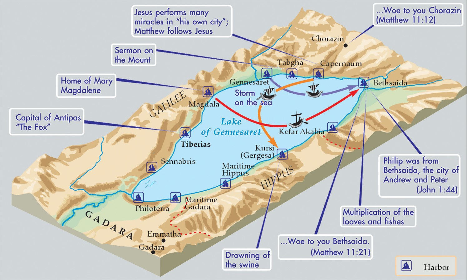
The most immediately useful part of the chapter was the 3-D map of the Lake of Gennesaret, also known as the Sea of Galilee. The map is followed in the text by descriptions of Tiberias, Capernaum, and the now elusive-to-locate Bethsaida. Here is the map, which you can click or open in a new tab/window to enlarge:
Around the Lake of Gennesaret (Sea of Galilee) (Carta’s caption)
And then there is the section, “The Sea of Galilee: Development of an Early Christian Toponym.” For as familiar as “the Sea of Galilee” is to the Christian lexicon, that place name only occurs, Notley rightly points out, in these verses: Matthew 4:18, 15:29; Mark 1:16, 3:7, 7:31; John 6:1. He convincingly notes:
The uncommon nature of this toponym is indicated in the Fourth Gospel by the Evangelist’s need to further define it with an additional genitive more familiar to his readers: “After this Jesus went to the other side of the Sea of Galilee [which is the Sea] of Tiberias” (Jn 6:1).
What then follows is an analysis of the references of Josephus, Pliny, and Maccabees to this lake. Notley’s command of Hebrew, Greek, Latin, and Aramaic help him to unpack for the reader, among other things, why this lake is called a “sea” (haven’t you always wondered?):
We are still left with the unusual application of the term θαλασσα by Matthew, Mark and John to the Lake of Gennesar, and the related question of the origins for the Christian toponym η θαλασσα της Γαλιλαιας (Mt 4:18, 15:29; Mk 1:16, 7:31; Jn 6:1). The name ים כנרת (Sea of Chinnereth) for the lake occurs three times in the Hebrew Scriptures (Num 34:11; Josh 12:3, 13:27) and is rendered by the Septuagint θαλασσα Χενερεθ (or Χεναρα).
But Notley is not convinced that Matthew, Mark, and John drew inspiration just from the Septuagint’s rendering of the Hebrew ים as θαλασσα.
Instead, the genesis for the Christian toponym may be indicated by Matthew’s scriptural citation immediately prior to his first use of the Sea of Galilee.
This uniquely “Christian toponym” of “the Sea of Galilee” has to do with how Matthew appropriated Isaiah 9:1:
Isaiah’s intentions notwithstanding, Matthew took advantage of the Septuagint’s rendering of the common noun גָּלִיל to read Galilee. Further, the Evangelist collapsed three widely divergent points of geographical reference to a single topos—the region around Capernaum that served as the locus for Jesus’ ministry.
And:
Drawing upon the Septuagintal vocabulary of Isaiah 9:1 (Θαλασσα and Γαλιλαια), the early Church created a new toponym that provided an elliptical allusion to Isaiah’s prophecy and underscored the biblical significance of the locus of Jesus’ ministry. If our observation is correct, we can now understand how the term Θαλασσα —which in the Septuagint’s translation of Isaiah initially spoke of the Mediterranean Sea—was transferred to another body of water, namely the Lake of Gennesar.
I appreciated Notley’s tentativeness in his conclusion (“If our observation is correct”). If the reader does not agree, she or he will still find Notley’s reasoning and detailed exposition compelling, even if a re-reading or two of his argument might be warranted. (And this is just one section of one chapter of The Sacred Bridge! The book is truly a gold mine.)
That’s not even to mention “The Last Days of Jesus,” a section in this same chapter that compellingly describes Jesus’ final journey to Jerusalem, culminating in his arrest and crucifixion. It is from this section that the graphic in my section 3 above comes.
5. The Younger Sibling of TSB
The Sacred Bridge is dense, technical, and not cheap. It’s worth its price ($120 retail, a little less at Amazon), but what about another way of accessing much of the same information and maps? TSB has a younger sibling, Carta’sNew Century Handbook and Atlas of the Bible (CNCHBAB).
CNCHBAB is less concerned than The Sacred Bridge is with “citing all available historical sources in their original languages.” The absence of such citations in “in their original script” is a main way in which the smaller Handbook differs from TSB.
Carta’s New Century Handbook and Atlas of the Bible is shorter, too. It omits almost all of the Excursuses of TSB, as well as omits a few whole chapters. The publisher describes it as “a select rather than a condensed version.” In “Historical Geography of the Gospels,” for example, TSB‘s detailed and technical (yet fascinating) section, “The Search for Bethsaida,” is left out altogether.
CNCHBAB is more accessible and cheaper (by about half) than The Sacred Bridge. There are entire sections in the Handbook and Atlas that appear verbatim as in The Sacred Bridge. This is good in terms of getting at the content of the latter, though not all potentially unfamiliar terminology has been explained or eliminated in the Handbook and Atlas:
The final phase of Herod’s palace in Jericho was the largest and most ornate. Concrete walls were faced with Roman-style plastering, opus reticulatum and opus quadratum, perhaps indicating the direct involvement of Roman builders and architects in the construction.
All the same, an advanced undergraduate course in religion or biblical studies could–with the guidance of the professor, as needed–make quite good use of Carta’s New Century Handbook and Atlas of the Bible for a textbook. For that matter, a seminary course could use it well, though any sort of doctoral studies–especially in archaeology or biblical geography–would call for use of the full Sacred Bridge.
6. A Few Points of Critique
My primary point of critique in using the print edition is that there is no Scripture reference index. It seems to me that one of the ways a person would come to the atlas is with a biblical verse or passage in mind, and want to find right away what TSB has on a passage under consideration. TSB in Accordance obviates the need for such an index, since one can use the Scripture search field to search the atlas by reference.
And this lack is not insurmountable in the print edition, as one can turn to the index to find any place names of interest in a particular passage. Besides, TSB covers so much primary literature, and deliberately seeks to address “every available documentary source,” such that to be true to its aim, a Scripture index would have to also be accompanied by other primary source indices. Given how many sources TSB cites, I understand the omission.
But, as noted in 1.C above, the index in TSB is well-produced, even without a Scripture index per se.
It would be unfair to fault an atlas with an academic audience for frequent use of technical terminology, so I point it out not as a critique, necessarily, but the reader should be advised of the need to know (or look up) words such as: steppe, opus reticulatum, legerdemain, sartorial, toparchy, etc. The occasional sentence, jargon aside, is lengthy and potentially difficult to follow on first read. But the overall style is readable and engaging.
7. EXCURSUS: My Seven-Year-Old Son Loved It
Bonus: TSB made for a good 20 minutes of bedtime reading with my seven-year-old son, shortly after I first received the atlas. (We’ve returned to it since then, too.) He knows the Hebrew alphabet and a little bit of Hebrew, and his Jewish friend at school had told him all about the Maccabees, so he loved looking and reading through the atlas with me! “Cool!” and “Wow!” were his most oft-used descriptors. Here he is:
Is TSB the Best Bible Atlas ever? Yes, without question. Is it worth the price? Yes, certainly.
When it comes to biblical cartography and historical geography, it doesn’t get any better, more thorough, or more interesting than The Sacred Bridge.
Here is TSB‘s product page for more information. You can also find the atlas here through Eisenbrauns, its North American distributor. Accordance has it available electronically, as well.
TSB‘s younger sibling, Carta’sNew Century Handbook and Atlas of the Bible, is here (Amazon), here (Carta), here (Eisenbrauns), or here (Accordance).
Many, many thanks to the fine folks at Carta and Eisenbrauns who set me up with a copy of TSB to review, both in print and Accordance. The publisher at Carta is one of the nicest and most interesting people with whom I’ve corresponded since starting Words on the Word more than two years ago.
As I have read and preached on some Psalms this summer, I’ve appreciated the importance of trying to practice intercultural sensitivity in reading the Bible (and in all of life).
I am working on a course on intercultural counseling this summer, one purpose of which has been to help build intercultural competence and sensitivity.
The readings, lectures, and class discussions have reminded me of the important truth that reading and interpreting the Bible is an exercise–whether we realize it or not–in intercultural relations.
Intercultural Sensitivity=Better Bible Reading
The culture, values, and practices, for instance, of ancient Israel differ from those of 21st century North America in a number of ways. If I read a passage with only an awareness of the cultural values I carry with me, I very well may miss an important truth or robust reading of a text. Or I may map a “truth” or value judgment onto the text that the author didn’t necessarily intend to be there.(I’m not discounting the potential value of so-called reader-response criticism, but I am suggesting we seek to avoid a monocultural or culturally hegemonic interpretation of a text, if possible.)
In a 2008 article for Journal of Spiritual Formation & Soul Care (“Relational Spirituality and Transformation: Risking Intimacy and Alterity”), Steven J. Sandage, Mary L. Jensen, and Daniel Jass write:
Since hermeneutical understanding is always intercultural and contextual, cultural self-awareness is a prerequisite to responsibly interpreting Scripture and spiritual experience.
I mentioned here how the idea of intercultural sensitivity helped me read Psalm 23 in a fuller way. The same thing happened as I prepared to preach on Psalm 46 this week. I got a little extra help this time from a Bible atlas I’ve been reading.
Psalm 46: God Is Our Refuge
Psalm 46 begins:
1 God is our refuge and strength,
an ever-present help in trouble.
2 Therefore we will not fear, though the earth give way
and the mountains fall into the heart of the sea,
3 though its waters roar and foam
and the mountains quake with their surging.
How should we understand the scenario the Sons of Korah (writers of this Psalm) describe?
The sons of Korah don’t just paint a picture of tragic events befalling God’s people—it’s the complete disintegration of all of life that is the dominant metaphor in these verses. A number of commentators point out here that the effective merging of the land (mountains) and waters (sea) harken back to the pre-creation state of chaos that existed before God separated the land from the waters, bringing order to life. The sons of Korah, then, describe a sort of uncreation.
But even in the midst of an envisioned chaos and uncreation of the world (!), “God is our refuge and strength.”
Verse 2 says, “though the earth give way,” or, though the land give way. Here is where an interculturally aware read of the Psalm helps it to come alive even more profoundly. (The below was inspired, in part, by Paul H. Wright’s Rose Then And Now Bible Map Atlas® With Biblical Background And Culture.)
Life for Israel: Location, Location, Location
Before there was such a thing as real estate, life for Israel already was location, location, location.
The topography or shape of the land had a lot to do with whether a given area would be suitable for habitation. Mountains, in particular, provided a sort of natural buffer of protection against enemies… a hiding place to run to, if need be. Water, of course, was necessary for life and the production of crops.
Mountains in Edom (photo: Garo Nalbandian, from Carta’s Sacred Bridge atlas)
The congregation of Israelites who would sing this Psalm understood their identity as intricately tied to the land. The land—which God had given them—was part and parcel of his covenant relationship with them. It was part of his blessing, a sign of his love. If we don’t have this land, how can we really call ourselves God’s people? This is still a live question for many.
Yet even if we were to lose this fundamental aspect of our identity, the Psalm declares, even if the world were to be uncreated and fall back into chaos, “we will not fear.”
The congregation can still say—can still sing, “God is our refuge and strength, an ever-present help in trouble.”
Given how important land was to the people of Israel and the construction of their collectivistic identity, this is an amazing affirmation of trust in God.
Intercultural Insight from a Bible Atlas
Paul H. Wright’s cultural awareness and sensitivity is present from the very first chapter (“The Landed Context of the Biblical Story”) of his biographically-arranged atlas:
To start, it is perhaps appropriate to define a few aspects of location that have impacted living conditions in the lands of the Bible over time. The building blocks of biblical geography include the following….
He lists topography, climate, and available resources. He goes on:
The particular mix of elements such as these plays a significant role in determining whether any given plot of ground can support permanent settlements and how large and well-established these might have become, or if the land is better suited for herding or desert lifestyles.
Here’s the intercultural piece, which I so appreciated:
Specific geographical realities have also helped to shape cultural values and norms that defined individual societies. For instance, protocols of cooperation, hospitality and defense that functioned well in arid, shepherding societies in biblical times developed differently than did those that attained to urban centers located in fertile areas, or to sailors who frequented foreign ports-of-call. And aspects of geography gave rise to specific images that biblical writers used to describe God and the people of ancient Israel.
Understanding the value of land to the people singing Psalm 46–it was an essential component of their identity and experience of God’s love for them!–makes the affirmation of trust in this Psalm even more remarkable.
Though the sons of Korah envision a scenario in which their land is gone–having slipped into the ocean–they call on the congregation to praise God still.
The above is adapted from a portion of a sermon I preached yesterday. Rose Publishing has sent me the Wright atlas for review purposes. A full review is forthcoming. You can find the atlas in the following places: Rose Publishing, Amazon (affiliate link), Carta (as Greatness, Grace, and Glory: Carta’s Atlas of Biblical Biography), and Eisenbrauns (same title as Carta).
One of many cool things about Carta’s Sacred Bridge atlas is its use of original/source languages.
For example, when The Sacred Bridge (TSB) cites Eusebius’s Onomasticon (a 4th century list of Bible place names), it does so both in its original Greek and in English translation.
This, of course, got me to wondering about Eusebius in Greek. Using The Sacred Bridge in Accordance, I can easily pull up all the times TSB cites Eusebius (more on this later).
Then I wanted to know where to find more Onomasticon in Greek.
After a short hunt, I found this digital edition of the Onomasticon in Greek. I thought I would pass it on in case anyone else using the atlas in English wanted to be able to access the Greek.
Eusebius’s Onomasticon (in English translation, and with English translation of Jerome’s Latin translation/expansion of Eusebius) is here in Accordance, here on Carta’s site, and here at Eisenbrauns, Carta’s North American distributor.
The one kind of blog post I’ve deliberately avoided till now is the “In the Mail” post. I have my reasons for this, but that’s not the point of this post. I simply wanted to say that the book I received in the mail the other day might be the first one that caused me to say, “Whoa,” when I opened to the front inside cover.
For future review I’ve received The Sacred Bridge: Carta’s Atlas of the Biblical World. This is the “Second Emended & Enhanced Edition” (copyright 2014). Here it is:
Carta Jerusalem, its publisher, describes the atlas in this way:
The Sacred Bridge will be the Bible Atlas of Record and Standard Work for the coming decades. Exhaustive in scope and rich in detail, with its comprehensive documentation of the Near Eastern Background to Biblical History, this latest Bible Atlas from Carta is one more stepping stone on the way to the study and understanding of the Holy Scriptures.
And:
This is the first Atlas to adopt the modern approach to the study of the Levant as a geographical/historical entity. Emphasis throughout the current work is on the ancient written sources – every ancient passage is interpreted firsthand, from its native language. Archaeological evidence has been taken into account whenever it is relevant.
Here is what’s inside the cover. You won’t be able to see much detail in the image (click image or open in new tab for larger), but it will give you an idea of the kind of thoroughness that seems to exist throughout the atlas. And that’s before you even get to the atlas itself.
I’m looking forward to digging in. It’s a beautiful, massive atlas, with a lot of text and full-color images packed into its large pages. The binding appears to be sewn, so it will last a long time. Here’s the product page for more information. You can also find the atlas here through Eisenbrauns, its North American distributor. More to follow.
Carl G. Rasmussen has recently released a Revised Edition of Zondervan Atlas of the Bible. Below I offer a description of its contents with some evaluative remarks.
What’s in the Atlas
After the Preface and Introduction the atlas consists of a Geographical Section and a Historical Section, followed by Appendices.
The Geographical Section is first, because:
This atlas has been written in the belief that once one has a basic understanding of the geography of the Middle East, one has a much better chance of coming to grips with the flow of historical events that occurred there.
After “Introduction to the Middle East as a Whole” there are these sub-sections:
The Geography of Israel and Jordan (the longest section, covering “the Five Zones,” weather, routes, and individual regions)
The Geography of Egypt
The Geography of Syria and Lebanon
The Geography of Mesopotamia
The Historical Section covers the Bible’s history in canonical order, from the pre-patriarchal period to the churches in Revelation. It concludes with a special section on Jerusalem (“Of all the cities in the Bible, this is the most prominent one: it is mentioned 667 times in the Old Testament and 139 times in the New”) and an essay: “The Disciplines of Historical Geography.” I appreciated being able to compare the layout of Jerusalem in the Old Testament, during the time of Nehemiah, and in the New Testament.
Rasmussen covers even the so-called intertestamental period, with sections on the Greeks (4th century B.C. onward), the Maccabees, and the Hasmonean dynasty.
The Appendices are also impressive. What really makes this atlas user-friendly is the 31-page Geographical Dictionary and Index. Any place name in the atlas (whether it has appeared on a map or in the descriptive text) is in the dictionary/index. There are also identifications with modern places, so one finds out, for example, that the biblical Bethany is the current-day El-Azariya. More specifically, here is the entry for Bethany at the back of the atlas:
Bethany (near Jerusalem)—Village on road to Jericho (Mark 11:1; Luke 19:29) less than 2 mi. from Jerusalem (John 11:18). Mary, Martha, and Lazarus lived there (John 11) and it seems that Jesus spent the evenings of the week before his crucifixion there. Mentioned 11 times in NT.–El-Azariya (174131), 1.5 mi. E of Jerusalem, on E side of Mount of Olives. 212, 214, 217, 251, 252
There’s quite a lot of text in the atlas, too. (It’s far more than just maps and photos.) In the section covering Jesus’ life, for example, Rasmussen offers an almost narrative overview of the locations of Jesus’ ministry, interspersed with graphics.
The Graphics
As with other Zondervan books along similar lines, there are striking full-color images and well-drawn maps throughout the book. Photographs like this will have to suffice until I can visit the lands described in this book:
Full-color photograph from the atlas
The atlas contains both two-dimensional and three-dimensional maps:
One of many maps from the Atlas
Between the maps, photographs, and timelines throughout the book, you can easily get your bearings in any era or biblical passage of study.
Evaluation
I’ve not been able to take full advantage of all that the atlas has to offer–there is a lot here–but it is my current go-to atlas. I look forward to making further use of it. Perhaps the proof is in the pudding: even though I was given a gratis copy for review by Zondervan, I purchased an electronic version of it in Accordance Bible software so I could have access to it there, too (I rarely purchase a book in two formats). Accordance’s production of the module, from what I’ve seen so far, enhances what is already an excellent book, with the added advantages of hyperlinks and advanced searching capabilities.
My two points of critique are fairly minor ones. First, the timelines throughout the book are easy enough to follow, but they are stylized in such a way that they feel a bit cluttered. You can see examples using the Search Inside feature on Amazon here (affiliate link). Second, the font is narrow and looks crammed on a page, especially pages that have a good amount of text. The flip-side to this is that in a book that is still fairly portable (just under 300 pages), you’re getting a lot of great information, but it’s not always easy to read for long stretches of time.
Any serious reader, no matter their level of prior knowledge of biblical geography and history, could make profitable use of the atlas. It’s not highly technical or scholarly, though students and professors should still consider it, especially in a classroom or Sunday school setting.
You can view a sample pdf of the atlas (including a detailed Table of Contents) here. Its product page at Zondervan is here. Accordance has it on sale for the rest of today (Monday) here.